Wednesday 30 April 2014

Z is for Zones - tidal Zones ...


Z is for Zones - Tidal Zones and where we clamber away into May and out of April’s A – Z ...
A rock at low tide, exhibiting
intertidal zonation - Kalaloch,
Washington USA


Z is for the foreshore Zones we find at the seaside ... some obvious, some not so apparent ... they range from ...


Eastbourne beach zonation clearly shown ... with me
standing on a bench!  This is taken from Helen's Gardens
higher up the cliffs, and west along the Promenade
 - Beachy Head is, to the west, behind me


... the splash or spray zone i.e. just above the high tide mark: land plants and animals that are adapted to salty conditions live here. 


Eastbourne beach with pier ... the spring water still
flows from below the shingle, banked up and
kept in place by the groynes


... lichens, which are fungi and algae growing in symbiotic partnership, are found here ...


Seaweeds growing on the groynes -
at this point they are about 8 feet above
the beach, and would be covered by
the high tide ... Bladder wrack - mature
 - with swollen tips; and green
spongomorpha - this is the common
breadcrumb sponge, found in shady
gulleys and under boulders on the lower
shore, or as here growing on the groynes


The strandline (ordinary high water mark), typically composed of debris, is an important habitat for a variety of animals ...


Limpets cling in the corner of the
groyne and its upright


... sandhoppers and seaweed fly are abundant on rotting seaweed, and these invertebrates provide food for shore birds, such as the rock pipit, turnstone and pied wagtail ... as well as small mammals ...


The Groynes and its cross strut, kept in situ with
large pebbles and stone


The lower limit of the splash zone is generally marked by barnacles ... the first truly marine creatures ...


The final run of groynes sunk
nearly at low water mark


The inter-tidal zone (between the tides), which is regularly covered and uncovered by seawater. 


Barnacles and borers near the low tide
mark - they are embedded or have bored
into the rocks


It extends from the barnacles down through the wrack seaweeds, to the low-tide area, where large kelp seaweeds begin to take over.


The rocky foreshore at a lowish tide


The third broad band is the sub-tidal (below the tides) zone, stretching from the kelp fringe into the permanent shallows.


A Ruddy Turnstone from Wiki


That is Z for Zones ... from a zoned out A-Zedder, who has a seized Z drive, more commonly known as a C drive,  and is ztruggling to zip her way around the blogozphere ... that is Z for the final day of the Aspects of British Coasts in 2014 ...
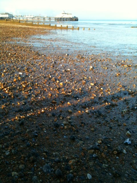


Some of the shingle, brought in by
man to shore up our beach front, and
help keep the town safe from storms;
with the pier and hardly visible across
Pevensey Bay is Hastings


By the photos ... you'll see I went to Eastbourne sea front last night ... and what did I see but the intertidal zone!!  


Surprised me too ... so hence lots of iphone photos ... to finally see Z out


PS I'm not ignoring you ... just struggling with technology .. but I zill be around and zee you all zoon ..... 


Hilary Melton-Butcher
Positive Letters Inspirational Stories


Tuesday 29 April 2014

Y is for Yorkshire coast, Youghal, Yew, Yellow flowers and butterflies, then yeasty saffron buns to sustain us ...


Y is for the east Yorkshire coast ... a beautiful area of north east England ...
 
Haydon Wyke, Yorkshire coast -
rock hopping


Y is for Youghal, a seaside resort in Co Cork, Ireland ...  this means “yew woods”, the trees at one stage being plentiful in the area ...


Youghal town harbour


... then Y is for Yew - among the hardest of the softwoods; yet it possesses a remarkable elasticity, making it ideal for products that require springiness, such as bows ...


1,600 year old Yew at
Estry, Normandy
... the trade of yew wood to England for longbows in the 1300 - 1500s was so robust that it depleted the stocks of good-quality, mature yew ...


... a serious shortage ensued ... Kings made orders ... but the Statute of Westminster in 1472 stipulated that every ship coming to an English port had to bring four bowstaves for every tun ... Richard III upped this to ten staves for every tun.

See Wiki under tun for more info

(A tun is an English unit of liquid volume (not weight) used for measuring wine, oil or honey ... typically a large vat or vessel, most often holding 252 wine gallons)


Sir Walter Raleigh (1554 – 1618), was Mayor of Youghal – here he is painted in miniature (c 1585) by Nicholas Hilliard (1547 – 1619), who was trained as a goldsmith and limner (illustrator of manuscripts).


Yellow horned poppy

Y is for Yellow horned poppy ...  a summer flowering plant that grows on the seashore and is never found inland ...


... it looks pretty – but is deadly ... being very toxic.


Robert Bridges (1844 – 1930) penned a short poem to the poppy:

A poppy grows upon the shore,
Bursts her twin cups in summer
Her leaves are glaucus-green and hoar,
Her petals yellow, delicate.
She has no lovers like the red,
That dances with the noble corn:
Her blossoms on the waves are shed,
Where she stand shivering and forlorn.


Sulphur Yellow Brimstone

Y is for the Yellow butterflies that migrate in from the continent ... our only native yellow butterfly is the sulphur yellow Brimstone ...


Cornish Saffron Bun


Y is for Yeast-levened sweet bun – a Cornish Saffron bun ... similar to the Swedish lussebulle or lussekatt, Norwegian lussekatt ...


Gorse covered cliffs above Bedruthan Steps,
north Cornwall 


That was Y for yodelling from the Cornish granites across the cliffs of Yellow Gorse ... to yet say yes to the Yew of Youghal ... and the Yorkshire coasts on the westerly winds ...


Yellow Wort
... knowing that a yellow Yeasty saffron bun can be munched on the strand surrounded by Yellow horned poppies, Yellow-wort on the dunes, under the yelping gulls and yawing red-billed choughs ...


Cloudy Yellow Butterfly


... while we wait for the Yellow butterflies migrating from southern Europe ... these are the Ys of the Aspects of British Coasts ...


I am in need of sustenance ... the machine is fixed pro-tem ... I might be moving into the 21st plus a decade century ... ie getting updated with all things ... sadly the saffron buns are in Cornwall!


Hilary Melton-Butcher
Positive Letters Inspirational Stories

Monday 28 April 2014

X is for facts of varying sorts... and Xanathoria ...


One X fact ... No Island is an island ... there be land beneath ‘dem seas and oceans ... before the seas formed the earth had just land ... strange but true!
 
No island is an island ... here the land is shown
stretching under the Ocean

2nd X fact:  The English Channel narrows to 34 km (21 miles) at the Straits of Dover. 

Great Britain and northern
Europe with the
Dogger Bank highlighted
in read

About 10,000 years ago Britain was not an island, but an upland region of continental NW Europe ...  the sea-level was about 120 metres (390 feet) lower than today.


... Doggerland, an area in the North Sea, was dry and acted as a land bridge across to the continent, until about 6,500 BC years ago.


As this part of northern Europe
would have appeared approx
10,000 years ago


... Great Britain lies on the European continental shelf ... an extended perimeter of each continent and associated coastal plain ... the shelf varies in depth from about (on Dogger Bank) 49 feet (15 m)  to 390feet (120 m) in the English Channel.


Chesil Beach from the Isle of Portland


3rd X fact:  Chesil Beach, which I mentioned in my H post as an inhospitable shingle beach for flora or fauna ...


... is now thought to be formed from the remnants of the flood of water and sediment that whizzed through from the North Sea to the Atlantic Ocean, leaving us with the body of water known as the English Channel, a result of the  Ice Age melt.  (Rather than a formation known as longshore drift – eg Dungeness, and Orford Ness).

 
Panorama of Chesil Beach and its fleet (lagoon)


4th X fact:  I’ve just found out there are fossilised ripples – so similar to myown picture of the sands at Perranporth at R – dating to about 240 million years ago ...

Fossilised Ripples - wave formation
ending up as fosslised ripples
c/o Southampton University


5th X fact:  The Dutch have about 450 miles of shore to protect ... whereas our shore line is over 7,000 miles – encircling our islands ... an impossibility to put up protective barriers ...


... the Thames Barrier is doing its work for now at the River Thames estuary entrance to London ...

Thames Barrier - the 'gates' are
able to be lowered in storms or
surge times

... but elsewhere we need to work with nature and use those flood plains as they were intended, or working within the rise and fall of sea levels – as has been done at the Somerset Levels ... see my R post (above).


Raised beach on Welsh coast
6th X fact:  We know sea level has always risen and fallen – the coastline shows us raised beaches – featured within the beds of exposed coastline ... 


... some from rising sea levels, at other times exacerbated due to the weight of ice – resulting in land mass tilt: pushed down in the north, raised beaches on the west, south and east shores ...


White Cliffs of Dover as seen
from Cap Gris Nez, France
7th X fact:  Sea-grasses are the only flowering plants in the sea ... these are essential as habitat protection for small marine animals ... the pipe-fish and sea-horses ... the grasses help gather sediment to keep the water healthy ...


8th X fact:  Oysters change from one gender to another and back again, depending on which is best for attracting a mate at that point in time.

 
From Anglesey looking across the
Menai Straits to Snowdonia, Wales
9th X fact:  Puffins are incredible divers and can reach depths of 60 m (197 feet) to catch fish.  They use their wings to propel themselves underwater and can carry several fish at a time back to the surface.


10th X fact:  Our most dangerous sea creature when the warmer currents bring them north to our shores is the Portuguese Man of War ... it has tentacles that can reach 15m (49 feet) in length ...  (J post)

 
Mugdrum Island, Fife -
as seen from Carpow Hill
11th X fact:  Do fish sleep?  Not really as they cannot close their eyes, and some fish never stop moving; however most fish have rest periods, when they just float or nest in a quiet spot, while remaining semi-alert.


12th X fact: humans swim at less than 1 mph (1.6 k/ph), while seals swim at an average speed of 12 mph (19 k/ph) ...


Xanthoria Parietina
Then one real X – the Xanthoria parietina ... has the name shore lichen depicting when it grows on rocks near the sea shore line ... it is a versatile lichen growing in damp areas and particularly wherever enriched via bird droppings ...


That is X for many X facts, but even the coasts can give us at least one real X genus, the Xanthoria, a versatile lichen, that are part of the series Aspects of British Coasts ...


I'm having a few problems with my machine .. so if I'm not around ... I'll be back tomorrow (Monday)  after it's fixed ...

Hilary Melton-Butcher

Positive Letters Inspirational Stories