Monday 30 April 2018

We are the World Blogfest ... # 13 - South Africans leading the way to help power Africa ...


I spotted this article ... how 'Clean Coal could help power Africa' - South Africa is leading the way ... Witswaterand (Ridge of White Waters) University in Jo'burg has a Sustainable Coal Research Group ....

c/o Daily Maverick
c/o Clean Coal is the Way Forward

Professor Rosemary Falcon (see article) together with chemical engineer Dr Nandi Malumbazo from Wits, Dr Samson Bada from Nigeria, along with Dr Jacob Masiala from the Congo are working on ways to get the lights on in Africa and keep the air clean.


The Professor can tell where coal comes from ... each continent and country will have a different recipe of minerals and fossil matter ... 


Southern Africa: The mustard colour is where coal is found ...
the other colours denote other type of rocks.
NB these rocks were deposited in a vast inland lake
or sea ... when Africa was part of Gondwana land
See Wiki

... South African coal was formed at the end of an ice age burning longer and at a high temperature - while the coal in North America came from hot steamy swamps and burns rapidly.


South African coal burns so hot that it would melt a European industrial boiler ... that made me sit up and think ...


... the challenge, which these academics are addressing, is to get the coal to a stage at the mine to be appropriate for its subsequent use, or build equipment and plants designed for each coal type ...


Africa's use of coal is growing rapidly as demand for energy grows ... and this research aims to produce 'clean coal' from the mine ... i.e. taking away the bits that will not help the burn, but leave fewer fumes, more heat and a better burn ...


I just found the article so interesting ... with all the talk being against coal ... their research seems like a positive way forward for Africa - but very possibly for other countries around the world.


Wits have proved that clean coal is not only possible, but among the cheapest ways to generate electricity on a continent where more than half the population of 1.24 billion Africans live without power ...


...  yet they have the same aspirations as every person in the Western World, China and Russia ... they should have electricity on tap ... to run their lives, as well as to power water, cities, factories, mines, schools and hospitals ...


... electricity is just not an ethical issue, it's the key to security and growth ... both in Africa and other parts of the world ... something we need to encourage Wits' work ...

We are the World ...
in darkness, be light


... and what an appropriate post for our maxim for this monthly blogfest that we participate in #WATWB

We are the World - In Darkness, Be Light

I'm linking to my U for Union Bay post in the A-Z as it features the development of coal on Vancouver Island ...

Hilary Melton-Butcher
Positive Letters Inspirational Story

Z is for Zunoqua ...


Zunoqua of the Cat Village ... an art work by Emily Carr, see K for Klee Wyck post ...

 
Emily Carr's
'Zunoqua of the Cat Village'
... Emily became 'bewitched' by D'Sonoqua and searched out this "Wild Woman of the Woods" ... usually finding her in the dead bole of a tall full cedar ... this D'Sonoqua ... alive as the depth and charm of the whole forest ...


Emily writes: 


'There we were D'Sonoqua, the cats and I - the woman who only a few moments ago had forced herself to come behind the houses in trembling fear of the "wild woman of the woods" - wild in the sense that forest-creatures are wild - shy, untouchable.'


c/o World Atlas


Emily had sat down to sketch ... when 'cats galore' came out of the trees ... purring furiously while rubbing and going on about her feet ...


This ends my rather eclectic take on things Canada ...


While Emily's Zunoqua inspired zee end and my Z post ... from Aspects by a British 'girl' in Canada ... 


Vancouver Art Gallery: Modernism and Late Totems (1927 - 1932) give some detailed information on Emily's work during this time.


Klee Wyck ("Laughing One") as Emily was known by the Native people: I wrote about in my K post ...


Zee end ... I do have quite a lot more relative to my A-Z posts to put up at some stage ... so may do a 'zummary post' in due course ...


Hilary Melton-Butcher
Positive Letters Inspirational Stories

Saturday 28 April 2018

Y is for Yukon ...


You might have guessed I'd be doing Yukon for the 'Y' post ... and yes once again I'm learning ... 

Map of Yukon from Wiki


Its name comes from the Gwich'in word Yu-kun-ah meaning "white water river" - referencing the glacial runoff in the Yukon River. 


The river rises in British Columbia, runs through the Yukon and out into the Bering Sea.  It is the fifth-longest river in North America, with about a third running through the Yukon; and is 3,185 km /1,980 miles long ...


Municipalities of Yukon - with the river
running through Whitehorse, and on to Dawson

 The Yukon is the smallest and westernmost of Canada's three federal territories ... and is 'sort of triangular' in shape ... bordering the Arctic Ocean to the north, Alaska to the west, Northern Territories to the east and British Columbia to the south ... it does not have a boundary with the Pacific.


Chilcoot Pass - c 1898
Geographically, as you might expect, it is a subarctic plateau interspersed by mountains ... the Arctic coastal plain has a tundra climate.


Historically though it is indelibly associated with the Klondike Gold Rush.


Showing route through from Skagway
up to the Klondike


Before we get there ... in other words long before the arrival of Europeans, central and southern Yukon was populated by First Nations people, as the area escaped glaciation. 


Archaeological sites for example those in the Old Crow basin, north of the Arctic Circle, place the arrival of humans at least as early as 10,000 BCE and possibly much earlier.


The volcanic eruption of Mount Churchill in approximately 800AD, in what is now Alaska, blanketed the southern Yukon with a layer of ash ... which apparently can still be seen along the Klondike Highway ... and which forms part of the oral tradition of the First Nations peoples in Yukon and further south in Canada.


Skookum Jim - worked as a
packer on the Chilcoot Pass
Coastal and inland First Nations had extensive trading networks ... European incursions only began in the 1700s/ early 1800s with the fur trade, followed by missionaries.  Then the Gold Rush ...


Downtown Whitehorse

The 'new' capital (1953) of Whitehorse has 70% of Yukon's  population living in it ... (25,085: year c 2016) ... its name deriving from the rapids resembling a horse's mane.


Dawson, the previous capital, was at the centre of the Klondike Gold Rush, and surprisingly for a short period was the largest city north of Seattle and west of Winnipeg.

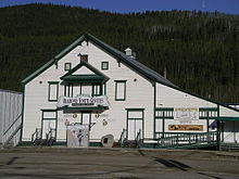
Diamond Tooth Gergies - Gambling Hall
which will give you the experience!


It lies in traditional Tr'ondëk Hwëch'in territory being named after Canadian government geologist Dr GM Dawson.


Most of the 'gold rushing miners' travelled up via what I term as the Glacier Bay fjord area and Skagway ... though there was a secondary sea route around Alaska ...


Sea Route for prospectors, and various
entourages
The Gold Rush only lasted a couple of years (1897 - 1899) ... it was estimated that a migration of about 100,000 prospectors battled through ... just over a century later the population is about 1,375 ...


... yet Dawson City is still a gold mining centre ... but the main activity now is tourism, based on the area's colourful past and historical importance.


There's a lot more interesting history ... so there will be another Y for Yukon post at some stage ... as it'll be good to have it linked here ...


That is Y for Yukon ... from Aspects by a British 'girl' in Canada ...

Hilary Melton-Butcher
Positive Letters Inspirational Stories

Friday 27 April 2018

X is for Xylem ...


Well this one was easy ... and I learnt to spell it ... with an 'e' and not an 'u' ... Xylem - one type of transport tissue in vascular plants ... 
This is some inside-bark that I saw earlier
in the year here on the farm ... and knew!! it
could fit my X post ... which is what - X or P
 I've no idea!! but did like the bark.


... Phlöem is the other ... both surround the central core of a tree or stem ...


... now I need to explain it to you!!  Xylem is the woody central tissue ...


... while the outer is called the phlöem - or bast (a more delicate tissue) ... this is the inner bark of trees from which ropes were made ...


Xylem schematic from Wiki
8 = Xylem, 9 = Phloem,
10 = the vascular bundle
The Xylem conduct water and nutrients (mineral salts)  upwards from the roots to all other parts of the plant, and in my case long tall trees ... like those we get here on the Island and many throughout Canada ...

Red Cedar bark


As we are now at X ... I think this is elegantly sufficient to send you to other blogs and/or to remind you two more days then we will have happily sent our Xylem around the blogosphere - and the month of May bliss will have arrived.


That is X for Xylem ... from Aspects by a British 'girl' in Canada ...


Hilary Melton-Butcher
Positive Letters Inspirational Stories

Thursday 26 April 2018

W is for Watersheds ...


Believe it or not this should be fairly simple ... water starts at the Snow Dome, Columbia Icefield  ... and travels to five different oceans/seas ...


See link below - Watershed assessment

Pacific - the largest rivers being the Fraser, the Yukon and the Columbia ...

Arctic (water that flows into the Arctic or into channels of the Arctic Islands) - the largest river is the Mackenzie: it is Canada's largest river basin, and the tenth largest in the world ...

Hudson Bay - approximately 30% of Canada's water drains into this watershed.  (While Hudson Bay, James Bay, Ungava Bay and Foxe Basin are referred to as part of the Hudson Bay drainage area).  The rivers are the Nelson, Churchill and La Grand Rivière.

Atlantic - most drainage basins in eastern Canada and the Maritimes flow to the Atlantic, particularly the Great Lakes-St Lawrence system.

 ... and even as far south as Mexico - a small portion of freshwater via the Milk River, which is the northernmost tributary, into the Missouri-Mississippi system ...

There are closed drainage systems in Alberta and Saskatchewan ...

 
For original see Wiki: Snow Dome

The Snow Dome is where the Banff and  Jasper National Parks meet the borders of Alberta and British Columbia ... so named by J Norman Collie in 1898 - where the mountain reaches a height of 3,456m (11,339 feet) as he thought it  likely that it is the hydrological apex of North America ...


However, America could have claim to this via the Triple Divide Peak in Glacier National Park, Montana - but we're talking Canada ... so I'll stick with Snow Dome!!


I think these two maps explain the watersheds perfectly ... and I'll leave this as a very simple 'W' ...


That is W for a very wet wide-reaching Watersheds post  ... from Aspects by a British 'girl' in Canada ...

For more information please see these two sites:

Canadian Geographic - The Atlas ... Watershed ...

Environment and Climate Change Canada - Watershed Assessment ...

Hilary Melton-Butcher
Positive Letters Inspirational Stories

Wednesday 25 April 2018

V is for Vancouver ...


How could I not do Vancouver, though could have chosen Victoria, now the capital of Vancouver Island.


Location of Vancouver within
metro-Vancouver
Vancouver in the late 1800s displaced Victoria as the leading commercial centre on Canada's west coast ... in part due to the prosperity arising from the Klondike Gold Rush and the arrival of the railways 1880s, which soon, in the main, superseded other modes of inland transport.


Early 20th C Vancouver developed its markets for fish, minerals and lumber - then the First World War severely declined economic prosperity ...


Stanley Park
... the 1920s growth resumed and the export grain trade held up during the Great Depression of the 1930s ... while its mild climate became a draw for many peoples ... this led to Vancouver replacing Winnipeg as the leading city in western Canada.


Port of Vancouver

... the outbreak of the Second World War ended unemployment, trade grew particularly through shipments of wheat to China.


I highly recommend this
saga - see note below


But ... the early settlers in the 1850s in the western coasts and Vancouver areas largely ignored the Indigenous members of the Coastal Salish linquistic group ... 'just taking their land' by proclamation under the Crown ...


The Speaker figure - Brooklyn Museum
19thC - the voice at the Potlatch ceremony

The Indigenous Peoples had been here for over 8,000 years ... and through the abundance found on the coast enabled them to live in larger, more socially stratified groups than was typical among Indigenous peoples in Canada. 


Their great wealth and complex social organisation produced elaborate cultural institutions as exemplified by the potlatch ceremony.


Vancouver's Chinatown - the largest
in Canada

... during the eighty years or so from the mid 1800s to the outbreak of WW2 many peoples from a wide range of countries had by choice, or by offer of employment, or by dubious coercive offers of employment had entered Canada via Vancouver ...*


... apart from the Europeans ... Chinese, Indians (Punjabis), Japanese made up most of the early immigrants obtaining work in the mines and thus establishing 'neighbourhoods' ... there are now many other different cultural areas ...


Statue of "Gassy" Jack in the historic
area of Gastown
Gastown was Vancouver's first downtown 'centre', named after "Gassy" Jack Deighton, a Yorkshire seaman, steamboat captain and barkeeper, who arrived in 1867 opening its first saloon.


Gassy Jack's tavern led to other stores and hotels appearing, which in turn led to the Canadian Pacific Railway extending westwards to take advantage of the large natural seaport - which became the vital link in a trade route between the Orient/Asia, Eastern Canada and Europe ...


Collage of the area


Now Vancouver is known the world over as the 'go to place' ... wonderful shoreline, stunning British Columbian interior, snow to enjoy, nature to explore, a multi-cultural diversity of ethnic groups ...


... offering delicious foods, choices of art theatre, music, film ... it is a film production centre - earning it the nickname "Hollywood North" ... and even the TED Conference has made Vancouver its home.


Vancouver was never recognised in his day -
yet posthumously has been.
It is thought that this recently found painting
might be of Captain Vancouver
To conclude this long post ... the city takes its name from George Vancouver (1757 - 1798) ... who explored and charted North America's northwestern Pacific Coast regions, the Hawaiian Islands and the SW coast of Australia.


Vancouver was a British officer, yet the family name originates from the Dutch "Van Coevorden", denoting somebody from the city of Coevorden, Netherlands ...


That is V for Vancouver both vanquished and victorious ... from Aspects by a British 'girl' in Canada ...

I have recommended this book before - but I'd highly recommend 'Vancouver' that is a Saga, an absorbing historical chronicle of the American coastal northwest and its settlers from the Siberian people through to today ... 

* as happened in other parts of the world during WW2 ... any immigrant from an ethnic background would probably suffer from internment - this too was prevalent in Vancouver

Hilary Melton-Butcher
Positive Letters Inspirational Stories

Tuesday 24 April 2018

U is for Union Bay ...


This seemed a good choice for 'U' - as it tells the tale of an area born on coal, being wound down when the coal ran out then being reborn with new development on the coal slack mound deposits ...


Union village, now called Cumberland, was named after the Union Coal Company ... which in turn was named in honour of the 1871 Union of British Columbia with Canada.


This really did enlighten me on the
pioneering days and what it was like
to come from Scotland and make your
way - yes, he was one tough individual ...
but I learnt a lot of history, geography etc


My interest in the area was reading about how Robert Dunsmuir (1825 - 1889) came out from Scotland in 1850 ... first travelling to Fort Vancouver, before moving to the north of the Island, then to the Union Bay area.


Dunsmuir's mentor returned to Scotland, but Robert carried on working for the Hudson Bay Company negotiating with Governor Douglas to operate on his own behalf, further south on the Island.


I couldn't borrow it - as this was the
only copy - many wanted to read it - and
sadly many have gone awol - henc the notice
He rose to prominence through sheer hard work, canny ability - as a coal mine developer, owner and operator, a railway developer, industrialist and politician, becoming within twenty five years the richest man in British Columbia.


I drove up to Union Bay - its interesting history almost obscured by time - but I'm still enamoured with it ... and now I know the area - will return in due course.


Remnants of the area's historic use as a coal shipping terminal between 1888 and the 1960s can be found in the Bay ... black rock, pilings, bricks, rusting metal ... an industrial midden - which will await future archaeologists.


Beach 'midden' remnants littering the shoreline
c/o Island Nature - Union Bay Coal Hills


It is slowly being reclaimed ... but apart from huge logging booms in the deepwater Bay ... the area is now noted for its mussel, clam and oyster beds ... as well as fresh crabs ...


A beach full of mussels and mussel beds ...
it was a cool day ... but the coastline here on the west coast
is full of bays, inlets etc ...

Robert Dunsmuir enjoyed the high life after his hard work ... yet never managed to let go ... his fortune has gone, but he is remembered for opening up Vancouver Island ...


So tomorrow we go from here 'U' for Union Bay, Vancouver Island and its reincarnation in the 21st century  to Vancouver itself on the mainland.


That is U for the unique Union Bay ... from Aspects by a British 'girl' in Canada ...

'Midden' photo from Island Nature - wonderful photography and pertinent tales ...

The Dunsmuir Saga book by Terry Reksten ... brings their history to life - which covers the pioneering days here on the Island, together with changes occurring in the last 170 years ...it was a fortuitous 2nd hand buy in the very local bookstore.

Hilary Melton-Butcher
Positive Letters Inspirational Stories

Monday 23 April 2018

T is for Thuja Plicata and Totems ...


I am living 'down the road' from the City of Totems - Duncan ... it is not a city at all, but a town of 5,000 - in its early life it was classified as a city - and that's stuck.


The upper part of the body of
"The Feast" ... the bald eagle stands proud


I've iphoned a couple of totems in the 'city' the other day - not very good records ... but I'll take myself on a tour to see the 40+ poles in the town.  My photos aren't brilliant - but you'll get an idea and I will elaborate on the meanings of some of them anon.


Thuja Plicata

Thuja Plicata - the Western Red Cedar tree - known as the Mother Tree - is the tree of choice for these First Nation carvers.


For thousands of years, cedar sustained the peoples of the Northwest by providing material for everyday items: ceremonial masks, medicine, transportation, housing, fishing nets, food bowls, clothing, firewood, storage boxes and more...


However in 1986 ... Duncan was designated as the City of Totems ... being found in the Cowichan Valley, traditional home of the Quw'utsun' People.


A fuller version of "The Feast"
- with an historical caboose behind
In fact ... the totems on display in Duncan represent carvers from across the Pacific Northwest, Quebec and New Zealand ... and bear witness to the proud heritage of carving amongst the First Nations people.


A Totem pole
in Thunderbird
Park, Vancouver


I will later on go into more detail about these amazing poles ... but for now - the First Nations relied on oral tradition to record their history, the carved totem poles created a permanent record of their lineage and historical events.


Ceremonies are performed at each pole raising ... these have come to be a combination of traditions and protocols from both native and (today) non-native communities ...


... and remind us that there is a spiritual connection between man and tree, that we are all aspects of a greater whole ...


That is T for Thuja Plicata and Totems ... from Aspects by a British 'girl' in Canada ...


Hilary Melton-Butcher
Positive Letters Inspirational Stories